From a frontier village in the 1840s through its growth as a major continental crossroads of commerce and transportation to today’s Metropolis, Dallas has earned its reputation for sheer physical size. Dallas is the third-largest city in the State of Texas and the ninth-largest in the United States. The city covers nearly 500 square miles and is the county seat of Dallas County—the ninth most populous county in the country. City planning was a limited concept in the nineteenth century, but after 1900, the notion of planned or controlled city growth developed rapidly.*
The Kessler Plan – 1911
The Kessler Plan managed growth from 1910 through the 1930s and was authored by George E. Kessler, Dallas-raised city planner. In 1909, the Dallas Chamber of Commerce established the City Plan and Improvement League (later called the Kessler Plan Association) and hired Kessler to draft a design for a long-range plan of civic improvements. Kessler drew up his plan to solve many of the city's problems, including the uncontrollable flooding of the Trinity River, the dangerous railroad crossings, and the narrow, crooked downtown streets. The plan was not fully implemented at the time because it was not believed to be practical, but it became increasingly clear that changes were needed.
Kessler returned in 1918 to act as consulting engineer for the Dallas Property Owners' Association and in 1919 began working for the Metropolitan Development Association of the Dallas Chamber of Commerce. He remained in Dallas until 1922, when he returned to St. Louis. Although Kessler died in 1923, the Trinity River was straightened and the levee system was completed in the 1930s. In addition to Dallas, Kessler drafted city plans for Cincinnati, Indianapolis, Cleveland, El Paso, Denver, and Syracuse.
*Adapted and derived from original research and the following source: The Handbook of Texas (Texas State Historical Association)
The Ulrickson Plan – 1927
The Ulrickson plan was an ambitious nine-year capital budget program calling for the issuance of $23,900,000 in bonds to finance a variety of public works projects in the City of Dallas. The bond program passed in December 1927 and significantly affected the growth and development of the city.
Charles E. Ulrickson was appointed chair of a citizens committee formed to research and follow up on the 1911 master plan recommendations of planner George Kessler, including construction of levees on the Trinity River and large-scale street and sewer improvements. The Committee’s members included Alex F. Weisberg, Frank L. McNeny, Leslie A. Stemmons, and Harry Olmsted. Among the recommendations of the Committee were $8.5 million for water and wastewater system improvements and $5.5 million for streets and thoroughfare improvements. In addition to the levee and Trinity re-channeling program, the Committee’s greatest achievements were a system of viaducts or bridges across the Trinity and a “Central Boulevard” which materialized 20 years later as Central Expressway.
The Bartholomew Plan – 1944
At the prompting of Mayor J. Woodall Rodgers, the city council hired St. Louis city planner Harland Bartholomew to draft a new master plan for Dallas. The plan was initiated in December 1945 after voters approved $40 million worth of improvement bonds. The city expanded Love Field, began work on the expansion of the Garza-Little Elm Reservoir (renamed Lake Dallas and later, Lake Lewisville), and built Central Expressway, Memorial Auditorium, and the Dallas Public Library.
As well as quality-of-life matters, the Bartholomew Plan attempted to streamline government and augment the economic development capacity of Dallas. Bartholomew’s comprehensive plan for the City treated Dallas government as a “system of systems” needing structure and coordination. Though a long way from equality, the plan marked the first time the City of Dallas sought to improve African American neighborhoods and housing.
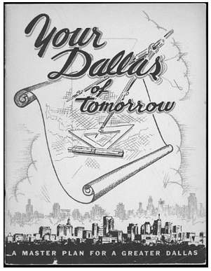
Your Dallas of Tomorrow plan from 1944. The Bartholomew Plan Collection.
Goals for Dallas – 1965
Out of the despair of the 1963 assassination of President Kennedy and the need to address issues of the “inner city,” the Goals for Dallas plan was initiated and orchestrated by Mayor J. Erik Jonsson and included a number of Dallas philanthropists and captains of industry. Although the plan was not initiated by the City of Dallas, it was endorsed by the Dallas City Council and was purportedly modeled after the corporate planning system developed by Jonsson’s business, Texas Instruments.
Citizen groups met to develop 100 goals on a range of topics such as improved public transportation, better schools and higher education opportunities, economic development and environmental quality. The process resulted in an expanded public library system, the Dallas County Community College District, a new city hall, a revamped University of Texas Southwestern Medical Center and the University of Texas at Dallas. While it did make many improvements, it did not achieve all of its goals and was criticized for neglecting some sectors of the city.
The Dallas Plan – 1992
In 1992, Mayor Steve Bartlett championed the "Dallas Plan," a vision for the following 25 years, which included a growth and economic development master plan and the origins of the present Trinity River Corridor Project. This $246 million plan called for construction of a network of parks and highways in the flood plain of the Trinity River. In 1994, the Dallas City Council adopted The Dallas Plan. Again, it was not initiated by the City of Dallas but was endorsed by city government.
Forward Dallas! – 2015
“Forward Dallas! Let's Build Our Future” is the latest planning program for the City of Dallas and the most intensive public-involvement planning project the city has ever undertaken. It is more comprehensive than any previous program for guiding growth and development and will build a long-range vision for the city that focuses on land use, transportation and mobility, and economic development. See the Forward Dallas! Website for more information: http://www.forwarddallas.org/index.php.
Manuscript and Paper-based Materials
The following collections are available for research in the Municipal Archives concerning city planning, zoning, and public infrastructure development:
Collection 1991-004—Kessler Plan, 1911-1930
Collection 1991-094—City Plan Commission Early Ordinances, 1929-1965
Collection 1991-095—Department of City Planning - includes some zoning, 1965-1987
Collection 1991-104—Bond Financed Capital Improvement Program, 1972-1973
Collection 1991-126—Thoroughfare Studies, 1970 and 1985
Collection 1992-034—Dallas Visions for Community, 1992
Collection 1994-024—Zoning Ordinance - University Park, 1991
Collection 1994-034—Designs for Dallas, 1970
Collection 1994-036—Comprehensive Zoning Ordinance, 1965
Collection 1994-054—Linear Waterway Study for the Farmer's Market Area of Downtown Dallas, 1991
Collection 1995-006—City of Dallas Planning Policies Guide, 1984
Collection 1995-034—Ulrickson Committee Report, 1927-1930
Collection 1996-010—City Plan Commission Membership List, 1919-1989
Collection 1996-016—Five Mile Creek Flood Plain Management Plan, 1976
Collection 1996-024—Central District Development Plan, 1970
Collection 1998-004—Bartholomew Plan, 1943-1957
Collection 1998-012—Capital Improvement Program - "Dallas at the Crossroads", 1967-1972
Collection 2002-004—Public Works and Transportation Department Photographs, 1926, 1944, 1972, 1979-1995
Collection 2003-001—Aerial Map Photographs of Dallas, Texas 1930, 1949, 1974, 1979
Collection 2005-001—Forward Dallas!
Collection 2006-001—Dallas Planning Department Publications and Related Materials, 1966-1990
Maps
Collection 1999-001—Map Collection, 1868
Maps created mostly by City departments for various city government functions, such as planning and public works. Maps often include city planning information about zoning, infrastructure, city limits, neighborhood development, and historic transportation details such as thoroughfares, interurban lines, bus lines, and train tracks.
Collection 1994-001—Annexation Plat Maps, 1890-1956
Maps created to accompany City of Dallas annexation ordinances.
Collection 2003-008—Planning Department Maps
Maps created specifically for purposes of short-term and long-term planning and zoning.
Collection 2006-001—Dallas Planning Department Publications and Related Materials, 1966-1990
Many maps and plans are contained within specific project studies and reports.
City Council Minutes, Ordinances, and Resolutions
Collection 1994-010—City Council Minutes - Bound Volumes, 1866-1977
Collection 1996-040—City Ordinances - Bound Volumes, 1871-1978
Dallas City Council’s official records, including minutes of the Dallas City Council (and earlier forms of government), from 1868 to the present, are available for research in paper, electronic, and micrographic forms.
Complete earlier records for 1868-1955 and 1977-1997 are available for viewing via paper and microfilm. Years 1956-1976 are available only on paper. They may be viewed at the Dallas Municipal Archives and Records Center. Original contracts and memoranda are not included in the microfiche; contact the Archives for details.
Council minutes, agendas, ordinances, and resolutions from 1995 to the present are available in electronic form on the City Secretary’s Office website.
City of Dallas Board and Commission Minutes
Collection 1999-004—City Plan Commission Minute Books, 1919-1983
Bound minutes from 1919-1983 on microfilm, unindexed; later years located in City Secretary’s Office files on microfiche by year and indexed. This Commission is responsible for making recommendations to the City Council regarding planning and zoning matters and is also involved in the platting and recording of subdivisions and additions. Early-day developers and key dates in developments are documented if they appeared before the Commission.
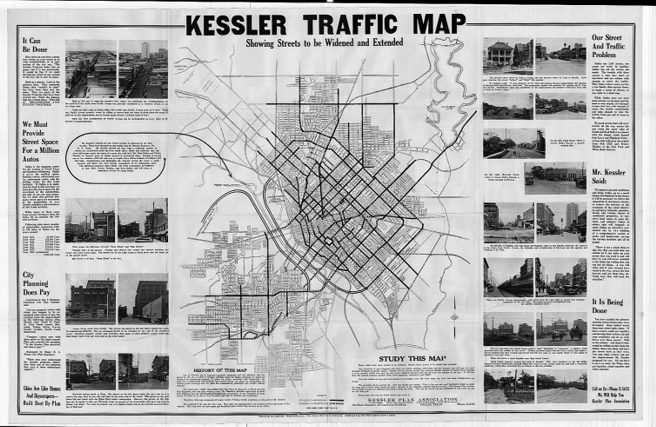
Kessler Plan Association Traffic Map, 1928. Kessler Plan Collection.
Note: Pathfinders are guides, they are not exhaustive lists. Review the full complement of Collection Guides to further your own research.